Land & Aerial Surveying Frequently Asked Questions
How do surveyors charge fees?
Surveyors generally charge fees based on the amount of time necessary to undertake the work. The hourly rate used is based on the qualifications and experience of the surveyor required for that project. The surveyor’s fees include survey equipment (minimum of $50,000 but often a lot more), a survey vehicle, office rent, specialised software, professional indemnity insurance, public liability insurance, other overheads, wages and profit. Daily rates for a single surveyor on a simple project are around $1,750.
The cheapest fee quoted may not be the best value for money. Consulting Surveyors Victoria (https://www.acsv.com.au/content/41/fees-residential-surveyors-and-land-survey-services.aspx) has a useful guide regarding fees.
How much does a land survey cost?
A very simple re-establishment or identification survey for a residential property would start at around $1,800. Complicated older areas, industrial and commercial sites will all cost more due to the complexities involved.
A simple residential Site Description or Survey Plan for a development application would start at around $2,400.
Who can define the boundaries of my land?
Only a surveyor registered or licensed with the relevant state government may legally undertake a boundary survey. This includes any survey, survey plan or sketch identifying boundaries. The identification of land boundaries means that the boundary is identified by, for example: bearings and distances; or offsets from structures.
For Victoria see Surveyors Registration Board of Victoria https://www.surveyorsboard.vic.gov.au/content/74/About-Cadastral-Surveying.aspx
For NSW see Board of Surveying and Spatial Information https://www.bossi.nsw.gov.au/
For Queensland see Surveyors Board of Queensland https://sbq.com.au/
Landair Surveys employs licensed and registered surveyors in Queensland, New South Wales and Victoria.
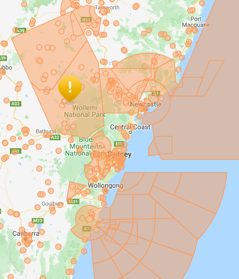
How can I find out if it is legal to fly a drone over my site?
You may be surprised that there are large parts of Australia where it is prohibited to fly a drone or where you need to obtain authorization from CASA or the military.
CASA has an interactive map that shows where a drone is prohibited from flying: https://opensky.wing.com/
The orange areas show where it is prohibited or where prior authorization is required.
In addition, CASA has strict rules about where a drone may be flown including:
- No flying closer than 30 m to people — other than those helping to fly or navigate your drone
- No flying over or above people at any time or height
- No flying in a way that creates a hazard to another person, aircraft or property
See Drone Safety Rules https://www.casa.gov.au/drones/rules/drone-safety-rules
Should a surveyor have insurance cover?
A professional surveyor should have:
- Workers compensation insurance to protect employees,
- Public Liability insurance to protect the public
- Professional Indemnity Insurance, to ensure that the any legal costs and claims for damages that may arise from an act, omission or breach of duty in the course of their business are covered
Without these insurances, if something goes wrong, the client will have to attempt to get compensation from the survey company or individual and they may not have the capacity to pay. At Landair Surveys, we have professional indemnity insurance of $10 million and public liability insurance of $20 million giving our clients peace of mind.