
Surveying for Architects
Across New South Wales and Victoria, Landair Surveys enables architects to design with precision by capturing intricate site features and building details using 3D laser scanning and reality capture.
Plan and design with confidence
Discover how Landair Surveys can elevate your architecture and heritage projects with precision-driven solutions.
-900x568.webp&w=1920&q=80)


-1440x810.webp&w=1920&q=80)


See successful projects with our partner architects.
We’ve worked with established architects across New South Wales and Victoria who value our clear communication and quality outcomes.


%2520(1)-640x405.webp&w=1920&q=80)


How we capture your architecture and heritage project
Feature and level surveys
Measure all external objects and topography to create site plan architecture that includes 2D site drawings and 3D contours. These plans help meet local council guidelines and accurately reflect existing site conditions.
Underground service locating
Identify and map underground services and buried infrastructure – such as electricity, water, gas and sewerage – and add the data to your existing conditions survey.
3D laser scanning
Use millimetre-precise architectural laser scanner technology to digitally capture facades, modern architecture floor plans, and internal structures. Ideal for custom home design, heritage conservation, and complex site analysis.
RPA flyover surveys
Capture whole-of-site imagery and surface models through aerial photography. This enhances floor plans, roof plans, and volume calculations — especially on large or inaccessible sites.
Title surveys
Calculate the position of your site’s title boundaries – and add existing easements to the survey plan.
Monitoring surveys
Continue measuring key locations on a building façade to track changes in movement and verticality over time.
Your quality data outcomes

Floorplans and RCPs
Develop existing floor plans and reflected ceiling plans using interior scanning data. Our services help bring your modern architecture floor plans to life with millimetre accuracy.

Façade elevation plans
Create elevation plans using external scanning survey data – that show architectural elements in detail.

Roof plans and imagery
Create high-resolution roof plans and imagery using reality capture techniques like RPA and 3D laser scanning. Useful for site planning, assessment reports, and volumetric studies.

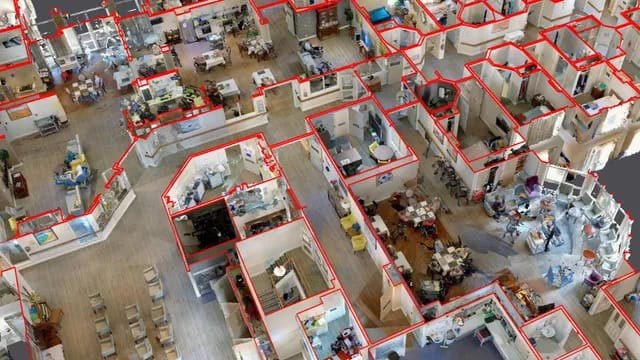
3D models and point clouds
Generate detailed 3D models and point clouds from laser scanning data. Delivered in Revit, AutoCAD, or LOD formats to support accurate site design, building analysis, and planning submissions.

Feature survey plans
Show existing building footprints, topography, and structures. These site plan architecture deliverables meet both design and compliance requirements across Victoria and New South Wales.

Section plans and verticality analyses
Processing scanning and monitoring data to show facade verticality and room-to-room site context.
Reality capture
We equip architects with complete reality capture of the site using advanced 3D scanners - including the Faro Focus S150+ and NavVis VLX3. Get full floor plans, building footprints and point clouds in the formats your team needs (AutoCAD, Revit).
View and measure every possible data point, from every angle and reference, to:
- Minimise disruption on your project and on-site risk.
- Save money and time by measuring all visible features the first time.
- Design with confidence that you fully understand every detail.
- Supports conservation, and compliance with local planning frameworks.
- Capture in square metres, volumes, and real-world measurements for reliable design inputs.
Never experience a data shortfall again, with a solid foundation for planning, design, remediation or condition assessments.
Why architects choose Landair for surveying.
We know how important it is for architects to understand every detail – from modern floor plans to decorative elements – down to the millimetre.
Landair Surveys makes precision and compliance a priority, using 3D scanning and site plan architecture expertise to deliver data architects can trust.
Your challenges
- Struggling to find surveyors who understand heritage overlays, conservation and architectural workflows?
- Need a partner who supports projects in Melbourne, Sydney and regional areas?
- Looking for surveyors who prioritise safe work, reliable data, and on-time delivery?
How we can help
- Our team has decades of experience with architects and on heritage sites.
- We’re known for capturing unmatched detail in areas like stone and brickwork.
- Our commitment is to go above and beyond for our architect partners.
- We’ve assisted with quoting and scoping projects, as well as grant applications.
- Our surveyors know your process and have the appropriate public liability insurance.
- We work fast to meet tight timeframes, especially around funding agreements.
Hear from our architect partners.
Meet our experts in surveying for architects.
When small measurement errors can lead to large design issues, architects across Melbourne and Sydney choose Landair Surveys for our specialist knowledge in 3D laser scanning, site plan architecture, and heritage data capture..


FAQs
As a general rule-of-thumb, the following accuracies can be expected from the technologies Landair utilizes:
- Stationary (static) laser scanner: up to +/- 3-5mm
- Mobile laser scanner: up to +/- 10-15mm
- Survey total station: +/- 3mm
- Survey-grade GNSS (GPS): +/-20mm
- RPA (drone): Horizontal +/- 20-50mm; Vertical +/- 150mm (largely dependent on surface reflectiveness, object contrast and consistent topography)
- Survey-grade dumpy level: Vertical +/- 1mm
Stationary, or static, scanners (Landair uses Faro Focus S150+ scanners) are set up on a tripod at each critical location and moved around the scene between scans. Sanning times at each location range between 2min and 10min depending on site constraints. Mobile scanners (Landair uses the wearable NavVis VLX3 scanner) run continuously as the surveyor walks through the scene capturing everything it sees on-the-fly.
Stationary scanners are more accurate, but the trade-off is the time spent on site. Mobile scanners allow quick measurement of a scene, but the trade-off is a slightly lower accuracy compared to stationary scanners. There are also different pointcloud formats, densities and ranges between the two scanning types. Please consult Landair’s 3D Laser Scanning Options for more details.
It varies project to project. While both include the foundational elements of walls, windows, doors, ceilings, columns, stairs, fences, etc., LOD400 includes the finer details like ceiling objects, wall fixtures, electrical equipment, rigid ducting, etc. Please consult Landair’s LOD Options as a guide for what’s included / excluded for the different levels.
Revit is predominantly a design platform. As such, it assumes straight walls, flat floors, consistent gradients, etc. Laser scanning, though, records buildings or infrastructure as-is – walls not perfectly square, floors not perfectly flat, etc. When a model is created in Revit from a pointcloud it is effectively dumbed-down to fit Revit’s design constraints. As such, a lowering of accuracy is inevitable. From experience, it’s not unusual to find differences of up to +/-20mm between objects in the 3D model and the corresponding points in the 3D pointcloud.
Landair Surveys is covered by $20,000,000 Public Liability Insurance and $10,000,000 Professional Indemnity.
We do. Landair utilises the Cintoo web-hosting platform to create online viewers. Cintoo allows specified users to take virtual walkthroughs of the laser scanning data. You can view in image mode (like Google Streetview) or in 3D surface mode and take ad-hoc measurements as required. Viewer access can be password protected for added security.
Most laser scanning quotes will include a nominal access period to Cintoo as a free value-add to our client. If useful, additional hosting time can be purchased based on the number of scans taken.
How long is a piece of string? Most of our field work for architects is completed within a day but major projects can be spread over a week depending on the complexities involved. The largest scanning job Landair has completed to date had the fieldwork spread over four weeks due to site constraints.
For smaller jobs, the required plans are usually completed within a few business days following the fieldwork. Larger projects have a data handover usually one to two weeks following fieldwork. Major projects and high-detailed modelling jobs will usually have final data handover two to four weeks following fieldwork.
For colourised pointclouds, high-resolution imagery is taken at each scanning location and the relevant RGB value of each image pixel is assigned to the corresponding scan points. This is good for most scanning environments. However, very dark or glary environments will significantly affect camera exposure leading to washed out pointcloud colouring. In such instances it is better to scan in greyscale format. A pseudo black-and-white image is created from the laser scanner’s intensity values to allow better viewing of the pointcloud.
Greyscale scanning is quicker than colour scanning due to the time spent for image capture at each scanning location. Most of Landair’s clients choose colour scanning for outdoor environments and greyscale scanning for internal environments to bring the overall scanning costs down.
You can, but you need to be aware of the limitations. Most architects will choose 3D modelling to align to LOD300 or LOD400. There are objects included in LOD400 modelling that aren’t in LOD300. For example, most wall fixtures (vents, lights, electrical equipment, decorative elements, etc) are not included in LOD300 modelling. Any façade elevation plan extracted from a LOD300 model won’t include such elements when they would probably be useful to show on a plan. The same applies to floorplans and RCPs.
If the preferred final deliverables are printed plans instead of electronic models, it is often better to draft façade plans, floorplans and RCPs directly from the pointcloud. That way, all desired elements are included.
Multiple scans are often required to measure everything within a scanning survey extent. This will mean the same real-world location can be measured by three or more scans. Even with a highly-accurate scanning control network and lots of overlapping linking targets, miniscule scanner and positional errors can lead to a spread of points for each real-world position. Usually, this point spread is within +/-3mm. However, black or highly reflective objects, shallow angle measurement and long scanning distances can affect recorded laser pulse values. This inevitably leads to increased ‘noise’ in the pointcloud.
When we create plans and models from the pointcloud we ignore the outliers and filter through the ‘noise’ to make sure what we provide represents what’s on site.
Major Building (LOD 400)
City Office (LOD 300)
Building Section (LOD 400)
Heritage Dome Pointcloud
Exisiting conditions Pointcloud
Medical suites (LOD400)
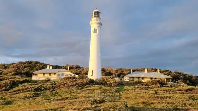
Our Projects

Former Land Titles Office, Melbourne

All Saints Church, St Kilda

Christ Church, St Kilda

Government House, Melbourne

Billilla Mansion, Brighton

Latvian Retirement Living, Wantirna South

Bendigo Hospital, Bendigo

Holmesglen Private Hospital, Moorabbin

Box Hill Hospital, Box Hill

Maroondah Hospital, Ringwood

John Fawkner Private Hospital, Coburg

Bendigo Town Hall

Collingwood Town Hall

Coombe Cottage, Coldstream

Coca-Cola Plant, Mordialloc

CSL Parkville

Bulla Foods, Colac

Little Creatures Brewery, Geelong

Citylink Tunnels, Melbourne

Exford Homestead, Melton South

Latrobe University, Bendigo

Caulfield Grammar School, Caulfield

Footscray High School, Footscray

Forum Theatre, Melbourne

Her Majesty’s Theatre, Melbourne

IBIS Hotel (Darling Harbour & Melbourne)

Magistrates Courts

Queen Victoria Women’s Centre, Melbourne

Traralgon Post Office

Theosophical Society Building, Melbourne

Pentridge Prison, Coburg

Royal Australasian College of Surgeons, Melbourne

Mission to Seafarers Building, Melbourne

Royal Exhibition Building, Melbourne

The Former Royal Mint, Melbourne

The Briars Historical Homestead, Mount Martha

Sacred Heart Manse, Carlton

Princess Theatre, Melbourne

Richmond Town Hall

Melbourne Town Hall

St John’s Anglican, Malvern East

St Patrick’s Cathedral

Supreme Court of Victoria, Melbourne

Parliament House, Melbourne

Wonthaggi State Coal Mine, Wonthaggi

Melton Police Station

Parks Victoria trail infrastructure

Victorian Institute of Forensic Medicine (VIFM), Southbank

Wonthaggi Hospital, Wonthaggi

Melbourne IVF, East Melbourne

Warrnambool Base Hospital, Warrnambool

St John of God Langmore Centre, Berwick

Wantirna Health Precinct

St George Preca PS, Caroline Springs

Monash University, Caulfield