Ground surveys
GNSS receivers and total stations capture the tops, toes and grades of stockpiles or waste cells to millimetre accuracy. Ground methods are viable in all weather and are ideal for small or complex areas.
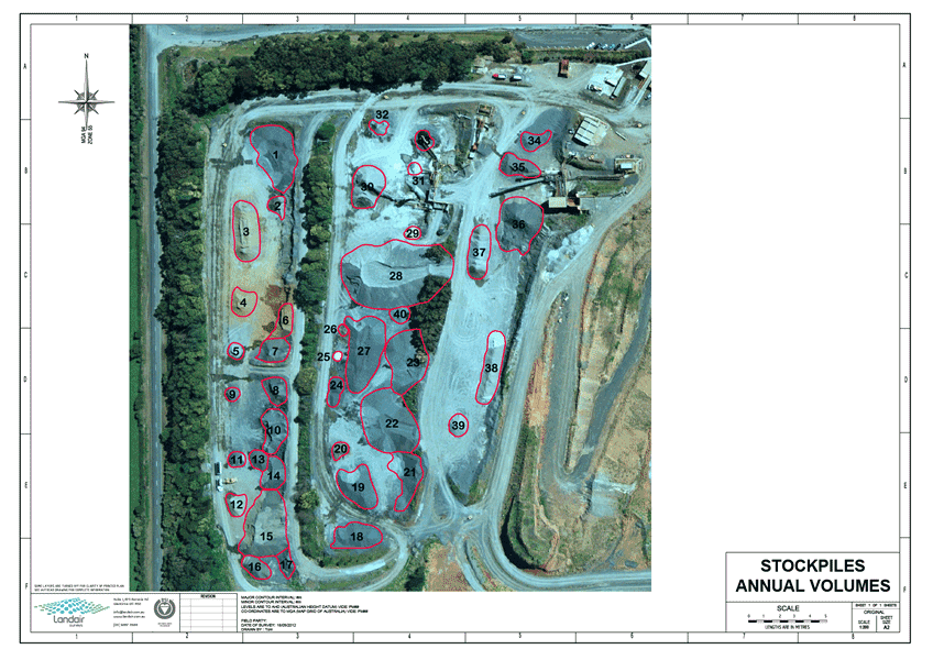
For landfill and quarry operators, understanding the movement and remaining capacity of material is central to safe and compliant site management. Volumetric surveys turn surface changes into measurable and verifiable data that reveal how airspace, waste or extraction areas are evolving over time. The results guide practical decisions on planning, rehabilitation and daily operations.
Landair Surveys applies proven ground, drone and aerial techniques to capture accurate, repeatable data that stand up to audit and analysis. Each survey aligns with previous datasets, building a consistent record that helps you see trends clearly and report with confidence.
Knowing exactly how much space has been filled (or how much remains) underpins every operational and compliance decision on a landfill or quarry site. Volumetric surveys are essential for:
Landair uses a mix of ground-based GPS, 3D laser scanning and RPA (drone) method, selecting the most efficient and accurate approach for each site. Whichever technique is used, our survey data is processed into accurate digital surface models for volume analysis.
GNSS receivers and total stations capture the tops, toes and grades of stockpiles or waste cells to millimetre accuracy. Ground methods are viable in all weather and are ideal for small or complex areas.
Drone flights rapidly map large or hazardous zones with centimetre-level precision. They’re ideal for regular airspace monitoring and stockpile assessments where access is limited.
For very large quarries or regional landfill networks, crewed aerial capture delivers wide-area coverage in a single sortie.
Monitor waste placement, track available airspace and demonstrate compliance with licence conditions.
Measure pit extraction, overburden removal and stockpile inventories for production control and royalty reporting.
Validate design surfaces, manage cut/fill balances and integrate models into project planning.
Landair delivers practical outputs that integrate directly with your workflows:
Tabulated quantities with date-stamped change analysis.
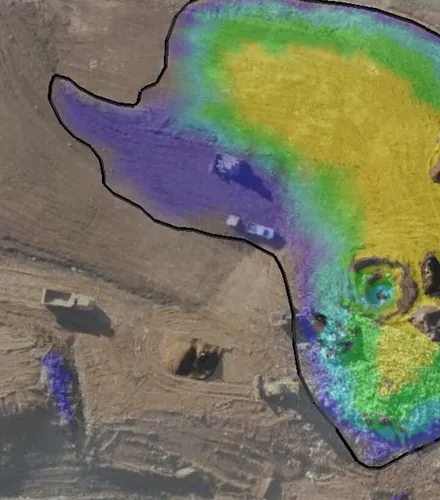
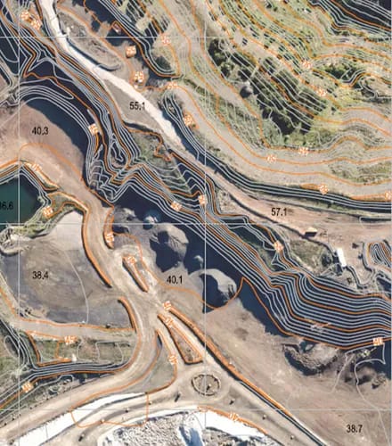
Surface-to-surface comparisons showing consumption and remaining airspace.
Georeferenced DTMs and DSMs for visualisation and planning.
Certified records for cell construction or rehabilitation sign-off.
Supplied in PDF, DWG, CSV or Propeller-compatible formats.
When precision volumes influence major operational and environmental decisions, you need a surveying partner who treats every cubic metre as critical data.
With decades of landfill and quarry experience, Landair understands the operational realities behind every dataset. We:

Maintain consistent reference grids to align historical and new surveys.

Provide clear, accessible reports and 3D visuals for non-technical stakeholders.

Integrate ground, drone and aerial data for comprehensive site coverage.

Deliver fast turnarounds while meeting accuracy and compliance standards.


